Leaning into Reciprocity, Collaboration, and Precision Techniques of the Day.
Landscape Management
Leaning into Reciprocity, Collaboration, and Precision Techniques of the Day
In 1865, Verplanck Colvin, a lawyer from Albany, New York, heeded his childhood passion for landscape and began exploring and sketching. The area that drew his attention would later become the Adirondack Park, a vast tract of land in the northern part of the state that he would help shape and define. Colvin – as it turned out – was more interested in the study of topography and geology than law, and devoted several years to scientific apprenticeship with astronomers and mathematicians. He also traveled to various places around the U.S., honing his drawing and mapping skills. His talent as a precision surveyor and free-hand artist would earn him a rare election to the Rocky Mountain Club in Denver.1,2
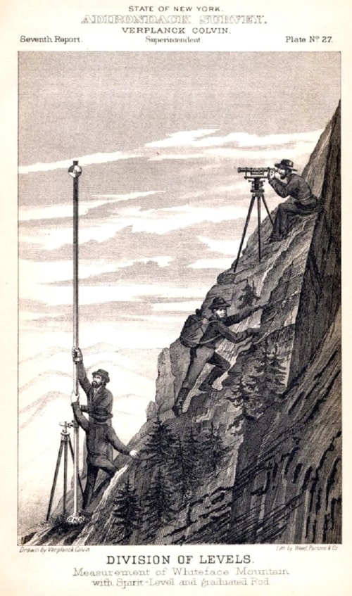
Measurement of Whiteface Mountain with spirit level and graduated rod. Drawing by Verplanck Colvin. Retrieved from Historic Saranac Wiki.
He became superintendent of The Adirondack Survey in 1872. And, at his urging, the state began to appropriate money for surveys. Throughout the next decade – equipped with a wye level and other modern-day precision surveying tools – Colvin and his team set to work to document the mountainous terrain. In 1878, he hired Seneca Ray Stoddard, a photographer, cartographer, writer, and lecturer who was also passionate about the region, to take charge of the New York State Topographical Survey of the Adirondacks.3 Their teams produced impressive documentation of the region that included both its wild beauty and the appalling effects of unchecked logging, deforestation, dams, and mining.
Adirondack Survey Camp Life, 1888. Colvin leans against the sole tree. Copyright Seneca Ray Stoddard. Special Collections, Feinberg Library, SUNY Plattsburgh.
Used with permission
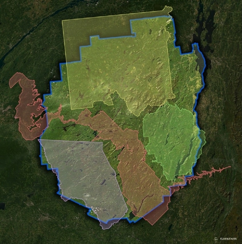
Over more than ten years, with persistent presentations to reluctant legislative bodies, Colvin and associates surveyed and documented in tracts and parcels, and argued the state should protect the acreage for future generations. Finally, in 1892, the Adirondack Park would receive its official designation. Interestingly, the 6-million-acre area – nearly 3 times the size of Yellowstone Park and legislatively protected as “forever wild,” has over 100 towns and villages and is described as “one of the few protected parks in which man and nature together have shaped the land and the landscape.”4
A to-scale size comparison of the Adirondack Park, which shows well-known U.S. parks Yellowstone (yellow), Yosemite (green), Grand Canyon (red), and Glacier (purple), all fitting within its borders.
Permission Carolyn Koestner, Geospatial and Environmental Scientist.
There are two points worth making here: 1 – that “forever wild” often confuses the public about pristine nature; and 2- man and nature have actually worked together for centuries, and that perhaps what is unique is that “White” [non-Indigenous] people are now learning how. As science journalist Claudia Geib writes in a recent article in Sapiens, “How Wilderness Was Invented without Indigenous People,” wild landscapes haven’t been pristine – without human intervention – for a long, long, time.5 And, she points out a reality many may be unaware of: that Indigenous people and practices intentionally shaped large expanses of land, over generations, with an eye toward reciprocity and interdependence.
Unfortunately, in many places, centuries of Colonial-industrialized approaches have ignored reciprocity and interdependence in favor of one-way extractive techniques. The problem with these techniques – beyond the obvious – is that they render invisible both the interdependent methodologies and the people who created them. This invisibility only further confuses today’s public about the length of human presence in landscape, and what constitutes damage and what constitutes wilderness.
In today’s Adirondack Park, logging is still practiced, though it is stringently regulated, and permits for residential, commercial, and industrial-mining uses are still granted. Maybe the park can serve as one type of model for the messy, complicated, and difficult process of managing modern-day, mixed-use wilderness planning, with community input and legal regulation, across a large landscape.
More than 150 years ago, people of diverse talents, equipped with precision tools of the day, collaborated in passion and persistence for thoughtful, long-term outcomes. I imagine their work echoed discovery and planning missions that occurred thousands of years prior. I wonder if reintroducing this type of example can influence a shift away from today’s efficiency-motivated extraction-depletion models toward an efficiency-motivated, regenerative-reciprocal-restorative model?
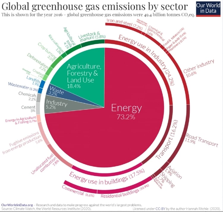
With this in mind, here are two infographics about land use from Our World in Data. A shared source of quality data seems like the right place to have informed conversations about how land is discussed and used.
Finally, a shout out to surveyors around the world – Global Surveying Day is celebrated on March 21. Thanks for the wonderful work you do!
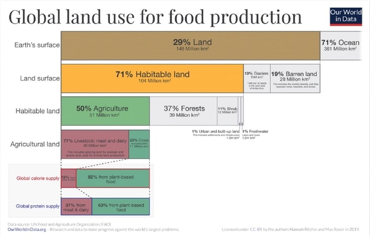
Our World in Data: Hannah Ritchie and Max Roser, 2019; Hannah Ritchie, 2020.
https://ourworldindata.org/greenhouse-gas-emissions and Emissions by Sector. “CO₂ and Greenhouse Gas Emissions”.
Published online at OurWorldInData.org.
Retrieved from: ‘https://ourworldindata.org/co2-and-other-greenhouse-gas-emissions’ [Online Resource]
Creative Commons BY license.