
If you are in large-scale land management, it’s likely you’ve heard of digital twin computing. Perhaps you have even experimented with it. In its basic form, digital twin computing (DTC) is a way to create virtual, dynamic models of things, systems, places, animal species, and even people. Enhanced with real-time data and machine learning, it aids with decision-making and enables land managers, researchers, designers, engineers, and others to experiment in a collaborative capacity with various potential future outcomes before enacting potential “solutions.”
While the concept isn’t new – it links back to NASA’s physical prototype modeling in the 1960s and ‘70s and to Michael Grieves, an expert in product life-cycle management who mapped its tenets in 2002 – DTC is being used by well-known multinational corporations and is trending up as a planning tool in support of Industry 4.0 and green infrastructure initiatives.

Additionally, its capability for sophisticated virtual and augmented modeling are considered to be a foundational technology for “smart” human societies, known in Japan as Society 5.0. 1,2,3
The EU is progressing with its own digital twin initiatives, among them Destination Earth (DestineE), which is an ambitious plan to create a digital model of Earth to explore natural and human activity; to study biodiversity, land use and natural resources; and to monitor the success of environmental policy while making its data sets public.4 For digital twin technology to succeed, however, more inclusive maps, modeling, and voices must be the new normal.
Seeing Land Management with New Eyes
As new technologies enable new approaches to land management, perhaps new descriptive words could help drive change. For example, the familiar land measurement term “acre” derives from Old English and once meant a piece of plowed land, or, as much land as a yoke of oxen and a ploughman could turn in one day. It has evolved into a basic scientific-legal unit of measurement that today equals 43,560 square feet or 4,840 square yards, or 4047 square meters.
“Acres” have been a convenient way to efficiently quantify what is being bought and sold, but simplifying land management to just acres not only depersonalizes place, it ignores the complexities of land. As many nations struggle with biodiversity loss and deforestation, few would argue with this observation that links to a depersonalized sense of place:
“…on almost every front, we have begun turning away from a felt relationship with the natural world.” The Wild Place – 2008
Robert Macfarlane, British author and naturalist
Depersonalized acreage is an outmoded approach because it leaves out the genius loci, or the pervading spirit of a place, everything that is inherent in the land, its power, its beauty, its healing and regenerative capabilities, its personal associations, and the myriad forms of life it supports. Because genius loci is unmeasured, however, all these obvious, observable, qualitative aspects are unrepresented and become a voiceless null, equal to zero on a balance sheet.
So, what about the spirit of the land beyond measured acreage? How to correctly represent things like water sources, ancestral hunting grounds, bird migration routes, and the burrows of wintering mammals? Is it possible to assign a digital or numeric value to the best places to view sunsets, or to hear the wind in the trees?
Instead of depersonalizing things further by making a reductive quantitative analysis, perhaps the way forward is by increasing the number and types of voices present at the decision-making table. Here are three inspirational examples of future-forward thinking that could help guide land-use leadership.
Expand the Conversation, Collaborate
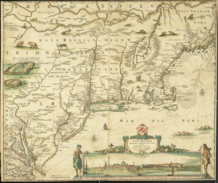
A map of New Netherland (New York), the first Dutch colony in North America.
https://www.nysl.nysed.gov
Countermapping is one way to assert an existence that has been denied. For example, in the U.S. and Australia, Colonial government surveyors and map makers were once able to solidify political and economic power by defining, naming, and controlling boundaries, or by limiting their maps to one-dimensional, Cartesian coordinates that plotted the location of resources and ownership.
One effect it had was reducing multiple realities of land and landscape known and experienced by Indigenous people, African Americans, and women; their realities could be concealed, overlooked, and made irrelevant.
With the stroke of a pen, thousands of years of vital information disappeared.
So, marginalized people have occasionally turned to making their own maps, which reflect a much different and often more complex truth about experiences of place than the mainstream narrative has been able or willing to accommodate.5,6
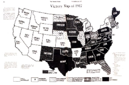
A countermap that illustrates women’s voting rights across the U.S.
https://www.nysl.nysed.gov
Listening to locals
As Japan continues forward with its vision for a technologically advanced, human-centered society, academic and corporate leaders have begun to recognize how important it is to make sure the systems being created are ones that citizens will want to use. In a recent interview with the president of Hokkaido University and the chief technology officer at Hitachi, this recognition emerged:
“If projects do not solve problems at the community level, they won’t do so on a global scale.”
Hideaki Koizumi, Emeritus Fellow, Hitachi 7
The forest of innovative collaboration
One example of innovative collaboration is at Hitachi’s Central Research Laboratory, named Kyōsō-no-Mori, which translates to “forest of innovative collaboration.” The lab, literally located in a forest of 30,000 trees, is bringing together technologists, engineers, designers, anthropologists, artists, and others for more informed decision-making to support commercialization decisions.
While face-to-face collaboration is preferred, the COVID pandemic offered another opportunity. The lab found that moving to online further lowered the barriers to participation.
“We have learned that, with lower barriers to participation, you can have discussions online involving a wide range of stakeholders, and that it is possible to get your message across and build empathy…” 8
Teams at the lab are also bringing new words into problem solving, such as “co-creation,” and “kazashi” or “future signs,” which infuse decision-making with flexible and reflective thinking sensitive to human needs.
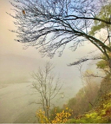
A current example of genius loci at Peebles Island, Waterford, NY. Photo by Susan Petrie.
Used with permission.
Industrialized approaches can extract resources efficiently. Satellites and drones can make meaning of land by analyzing pixels, and digital twin computing can come to learn and predict how these pixels of land may behave, respond, or be impacted over time — all very useful information. But this technology will be wasted unless a wide variety of human voices and human hands are guiding it.
And, while spirit of place will always evade true measurement, acknowledging it is a first right step for improved land management and use.